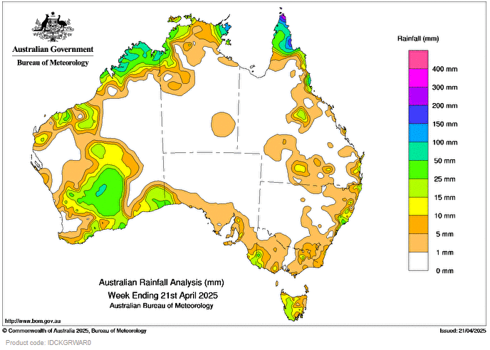
Ex-Tropical Cyclone Errol brought heavy rain to Western Australia’s Kimberley coast and adjacent inland areas on 18 and 19 April.
A tropical low embedded in a low pressure trough and onshore airflow resulted in heavy rainfall in northern Queensland, while thunderstorms brought showers to the Top End in the Northern Territory on most days during the week.
Thunderstorms developed across southern Western Australia on 16 and 17 April triggered by a low pressure trough, resulting in heavy rainfall across the Central Wheat Belt, Goldfields and inland parts of the South East Coastal districts.
Between 19 and 21 April, a cold front and the associated low pressure system brought cloudy skies and light to moderate showers to south-eastern parts of the country.
Rainfall totals greater than 50 mm were recorded in parts of western Kimberley in Western Australia and the Cape York Peninsula in Queensland, with some areas receiving more than 100 mm for the week.
Large parts of Western Australia, Tasmania and the Top End in the Northern Territory, as well as some scattered areas across the southern and eastern mainland coastline recorded between 10 and 50 mm during the week.
The highest weekly total (at a Bureau gauge) was 351.0 mm at Horn Island in Queensland and the highest daily total (at a Bureau gauge) was 160.8 mm at Kalumburu in Western Australia in the 24 hours to 9 am on 19 April.
HAVE YOUR SAY